Contents
hide
List of postal codes
| Place | Postal code |
|---|---|
| Alleyne School Road | BB25033 |
| Babylon Road | BB25036 |
| Bawdens | BB25023, BB25024, BB25025 |
| BawdensWalkers Road / Highway C | BB25026, BB25020 |
| Belleplaine Housing Area | BB25107, BB25034, BB25051 |
| Belleplaine Housing AreaBarbados H/est | BB25067 |
| Belleplaine Housing AreaBelleplaine | BB25079, BB25033 |
| Belleplaine Housing AreaBruce Valley/haggatt | BB25090 |
| Belleplaine Housing AreaCane Garden | BB25123, BB25124 |
| Belleplaine Housing AreaCorbin Village | BB25077 |
| Belleplaine Housing AreaWalkers | BB25029 |
| Belleplaine Housing AreaWhite Hill | BB25113, BB25115 |
| Belleplaine Housing AreaWorrell Vale | BB25032 |
| Boscobel – Highway B2 | BB25012 |
| Cambridge #1 | BB25072 |
| Chalky Mount | BB25078 |
| Chalky MountChalky Mount #1 | BB25089, BB25093 |
| Charles Duncan O’neal Highway | BB25012 |
| Church Gap | BB25051 |
| Coggins Hill | BB25093 |
| Corbins Village | BB25077, BB25081 |
| Diamond Corner – Highway B | BB25012 |
| Douglin Tenantry Road | BB25003, BB25015 |
| Ermy Bourne Highway | BB25031 |
| Farell’s Road | BB25031 |
| Franklyn Doughlin Tenantry Road | BB25034, BB25064 |
| Harewood Road | BB25052 |
| Highway 2 Haggatts | BB25035, BB25098, BB25103 |
| Highway 2 Walkers | BB25015 |
| Highway 2Belleplaine | BB25035, BB25094, BB25029 |
| Highway 2C – Dark Hole | BB25104 |
| Highway 2Cane Garden | BB25121, BB25107 |
| Highway 2Charles Duncan O’neal Highway | BB25012 |
| Highway 2Walkers Bay | BB25017 |
| Highway B – Shorey Village / Morgan Lewis | BB25001 |
| Hillaby | BB25046 |
| Hillaby/highway D | BB25053 |
| Isolation RoadBelleplaine | BB25065 |
| Isolation RoadBruce Valley / Haggatt | BB25090 |
| Jordan’s Road | BB25065, BB25033 |
| Jordan’s RoadA | BB25034 |
| King Street | BB25062 |
| Lakes | BB25081 |
| LakesLakes #1 | BB25081 |
| Mose Bottom Tenantry Road Turner Hall | BB25050 |
| Mose Bottom Tenantry RoadGregg Farm | BB25049 |
| Mount Hillaby | BB25114 |
| Redman Road | BB25029 |
| Redman Road Walkers | BB25036, BB25037 |
| Rose Hill Tenantry | BB25012 |
| Saddle Back | BB25100 |
| Savannah Road | BB25012 |
| Savannah Road Greenland | BB25003 |
| Savannah RoadGreenland Tenantry | BB25006 |
| Savannah RoadShorey Village | BB25007 |
| Sedge Pond | BB25012 |
| Spa Hill | BB25127 |
| St. Simons | BB25041, BB25060 |
| St. SimonsBruce Valley / Haggatt | BB25092, BB25090 |
| Turners Hall – Swann / Highway C | BB25044 |
| Turners Hall – Swann / Highway C Walkers | BB25026 |
| Turners Hall – Swann / Highway CBawdens | BB25025 |
| White Hill / Mount All | BB25107 |
| Worrell’s Road | BB25033 |
Search by Map
Find the postal code or address for any location in Saint Andrew, Barbados with our interactive map of zip codes. Simply click on the desired location on the map.
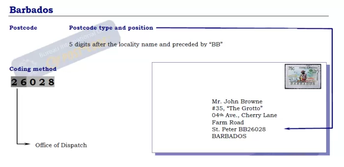
Barbados Zipcode Format

Find Postal Code
Each region in Saint Andrew has its own unique postal code, and it’s important to have the correct code to ensure timely delivery of your mail. To find the correct code for your destination region, simply click on the region in the list above. If you’re unsure which region to choose, try our address lookup tool at the top of the page or use our interactive map to find your zip code.